Cohutta Wilderness- Jacks River Loop | |||||||
| The Basics: | |||||||
| STATUS: | Cancelled - Hide from Calendar | ||||||
| Event Type: | Backpacking | ||||||
| Event Location: |
Cohutta Wilderness Area


| ||||||
| Date(s) & Time: | Sat, Aug 27 2016 7:30 am >> Sun, Aug 28 2016 6:30 pm (Carpool Departure: 7:30 am *log in for location*) | ||||||
| Registration Opens: | Tue, Aug 9 2016 8:00 pm | ||||||
| Registration Cut Off: | Thu, Aug 25 2016 12:00 pm | ||||||
| Event Duration: | 1 Days 11 Hours | ||||||
| Difficulty Rating: | D6: Advanced (Exploratory) | ||||||
| Distance: | 17 Miles | ||||||
| Pace: | Fast | ||||||
| Trip Leader(s): | Fardis Jane  Email Trip Leader(s) Email Trip Leader(s)
You must be logged in to get the Trip Leader contact information. | ||||||
| Member Cost: | None | ||||||
| Participant Info: | |||||||
| Who's Invited: | Members Only, 21 And Older Only | ||||||
| Maximum Group Size: | 8 | ||||||
| Minimum Group Size: | 3 | ||||||
| Number Registered So Far: | 3 / 0 (To see who's signed up, log in to the Member Area) | ||||||
| Are Dogs Permitted: | No | ||||||
|
Note: This is an "EXPLORATORY" trip. This means that there are parts of this trip, or perhaps the whole trip, that is new to your Trip Leader(s). However, they are confident that this will not be an issue. This note is here so that you can make an informed decision. When a Trip Leader isn't personally familiar with a trip, there is an increased chance of things not going as planned and you need to be prepared. The Trip Leader may have additional details in the itinerary. | |||||||
| Itinerary: | |||||||
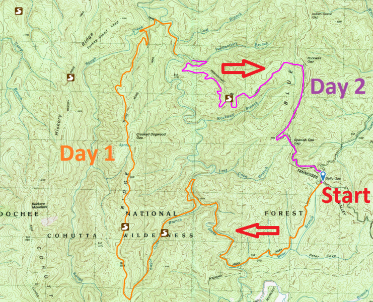
The Cohutta Wilderness covers 36,977 acres (about 60 square miles) that spill over the Georgia/Tennessee border and lie within the 95,265-acre Cohutta Wildlife Management Area. It was designated as a wilderness in 1975. Hemp Top was added in 1986, making this the third largest mountain wilderness area in the East. Please note this event covers a demanding route and we plan to move at a fast pace. If you have not completed a recent D5 hike/backpack or we have not been on an event previously, expect to have a conversation regarding fitness and capabilities. Itinerary: Day 1: 11.2 miles, 2194 ft ascent, 3037 descent 1. Start: Dally Gap 2. Jacks River Trail: 3.7 miles 3. Sugar Cove Trail: 2.1 miles 4. Rough Ridge Trail: 4.6 miles 5. End at Jacks River Trail: 0.7 miles We will leave the carpool at 7:30 (Busbee Park-N-Ride). We plan to reach the parking area (Dally Gap) by 10:00 AM and start hiking by 10:30 AM. We start at Jacks River trail head and hike 3.7 miles through the rocky Jacks River Gorge alongside several old growth hemlocks, lots of wildflowers, ferns and mushrooms. We turn left on Sugar Cove trail and continue for 2.1 miles before we turn right on Rough Ridge Trail. After hiking 4.6 miles north on this trail, we reach Jacks trail again. There is a campsite located there which should have plenty of flat spots. After setting up tents, we will start gathering fire wood for the evening. When we decide that we have enough we can walk about the mile to Jack’s River Falls and hang out, swim or wonder around. We will return to camp for dinner and comradeship over camp fire. Day 2: 5.3 miles, 898 ft ascent, 1671 ft descent 1. Start: Jacks River Trail: 0.7 miles 2. Penitentiary Branch Trail: 3.4 miles 3. Benton MacKaye Trail/Hemp Top Trail: 2.2 miles 4. End at Dally Gap After having breakfast around the camp fire, we will break camp and start hiking out no later than 10:00 AM via Penitentiary Branch trail. After 3.5 miles uphill, we reach Benton MacKaye Trail. From there is a 2.2 miles downhill to Dally gap. We can stop for a late lunch on the way back. Notes: We will have river crossings, so be prepared. Hydration will be of utmost importance. 3 L of water is recommended. Also, we may encounter yellow jackets so if you have a bee allergy please make sure you carry an EpiPen. | |||||||
| |||||||
| How to Get There: | |||||||
| Event Directions: | Directions: - Get on GA-5 N/I-575 N from George Busbee Pkwy NW and Chastain Rd NW - Follow GA-5 N to Whitepath Rd in Gilmer County - Turn left onto Whitepath Rd - Turn right onto Boardtown Rd - Turn left onto Bushyhead Rd - Turn left onto Cashes Valley Ln - Turn left onto Hwy 2/S R 2 - Turn right onto Forest Service Rd 22-2 - Continue for 3.5 miles to Dally Gap. Park at Dally Gap. Latitude: 34.9334134
| ||||||
| Carpool to Event Distance (round trip): | 160Mile(s) | ||||||
| Carpool Departure Time: | 7:30 am | ||||||
| Carpool Location: | Log in for location | ||||||
| Carpool Directions: | Log in for directions | ||||||
| Carpool Cost: | Estimated cost per vehicle for this event is $64.00 using a reimbursement rate guideline of $0.400 per mile. The total amount should be divided by the number of people in the vehicle, including the driver. This is a guideline, not a rule, for drivers but the cost should not be higher unless there are extenuating circumstances. | ||||||
| Notes: | |||||||
|
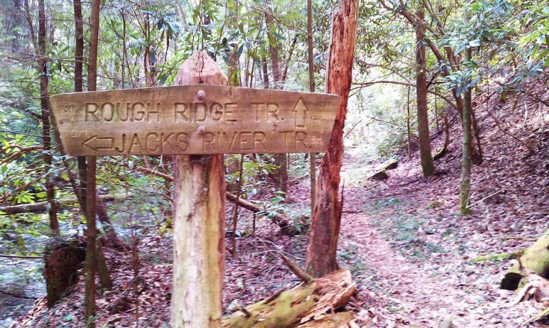
Here's a sign at the intersection of Rough Ridge Trail and Jack's River Trail which we will encounter after our second Jack's River crossing.
* We encourage all members to follow our Etiquette Guidelines while participating in AOC events. | |||||||
Cancellation/Partial Attendance: Please review the AOC cancellation policy. *Note: Please review our Cancellation Policy carefully! | |||||||

