High Falls Backpacking with optional standing Indian hike | |||||||
| The Basics: | |||||||
| Event Type: | Backpacking | ||||||
| Event Location: |
Beech Creek/Big Scaly Area, North Carolina


| ||||||
| Date(s) & Time: | Sat, Apr 14 2018 7:00 am >> Sun, Apr 15 2018 5:00 pm (Carpool Departure: 7:00 am *log in for location*) | ||||||
| Registration Opens: | Fri, Mar 30 2018 12:00 pm | ||||||
| Registration Cut Off: | Fri, Apr 13 2018 12:00 pm | ||||||
| Event Duration: | 1 Days 10 Hours | ||||||
| Difficulty Rating: | D4: Moderate to Difficult | ||||||
| Pace: | Moderate | ||||||
| Trip Leader(s): | Fardis Mark P  Email Trip Leader(s) Email Trip Leader(s)
You must be logged in to get the Trip Leader contact information. | ||||||
| Member Cost: | None | ||||||
| Participant Info: | |||||||
| Who's Invited: | Members Only, 21 And Older Only | ||||||
| Maximum Group Size: | 8 | ||||||
| Minimum Group Size: | 2 | ||||||
| Number Registered So Far: | 5 / 0 (To see who's signed up, log in to the Member Area) | ||||||
| Are Dogs Permitted: | Yes | ||||||
| Itinerary: | |||||||
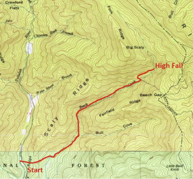
High Falls is a gorgeous fall (about 200 ft) located below Big Scaly and near Standing Indian Mountain. This is a great opportunity to see and enjoy its beauty and surroundings. Also if you want you can hike to Standing Indian summit (5,499 ft). The total distance hiked depends on you and can vary between 8 to 15 miles. From the trailhead to High Falls is 2.3 miles one way. From High Fall to campsite is around 2 miles. from campsite to cars is around 5 miles. We camp near the trail that goes to Big Scaly. First Day: After getting to our campsite everyone is free to explore. Or you can gather firewood and enjoy a relaxing day next to the campfire. I am planning to hike to Standing Indian and explore some trails. Second Day If the weather is nice We won't leave before 11. Bring lunch or snacks for after breakfast. We can stop for lunch at Clayton. If you prefer not to, arrange this at the carpool on Saturday morning, and bring enough food to sustain you until later Sunday afternoon. P.S. We have three dogs that accompany us on this trip Please arrive at the carpool location 10 minutes before departure time.
| |||||||
| |||||||
| How to Get There: | |||||||
| Event Directions: | for directions to trailhead click here: https://goo.gl/maps/U5hM9kKa Aq22). GPS: Tate City, Georgia 34.9953461, -83.5561566 | ||||||
| Carpool to Event Distance (round trip): | 210Mile(s) | ||||||
| Carpool Departure Time: | 7:00 am | ||||||
| Carpool Location: | Log in for location | ||||||
| Carpool Directions: | Log in for directions | ||||||
| Carpool Cost: | Estimated cost per vehicle for this event is $84.00 using a reimbursement rate guideline of $0.400 per mile. The total amount should be divided by the number of people in the vehicle, including the driver. This is a guideline, not a rule, for drivers but the cost should not be higher unless there are extenuating circumstances. | ||||||
| Notes: | |||||||
|
* We encourage all members to follow our Etiquette Guidelines while participating in AOC events. | |||||||
Cancellation/Partial Attendance: Please review the AOC cancellation policy. | |||||||
