Total Eclipse of the Supermoon! A special Skygazing Night Hike at Mason Mill Park | |||||||
| The Basics: | |||||||
| Event Type: | Hike | ||||||
| Event Location: |
NE Atlanta near Clairmont Rd & I-85


| ||||||
| Date(s) & Time: | Sun, Jan 20 2019 10:00 pm >> Mon, Jan 21 2019 12:00 am | ||||||
| Registration Opens: | Wed, Jan 9 2019 12:00 pm | ||||||
| Registration Cut Off: | Sun, Jan 20 2019 7:00 pm | ||||||
| Event Duration: | 2 Hours | ||||||
| Difficulty Rating: | D1: Easy | ||||||
| Distance: | 2 Miles | ||||||
| Pace: | Leisurely | ||||||
| Trip Leader(s): | Charlie Cottingham Email Trip Leader(s) Email Trip Leader(s)
You must be logged in to get the Trip Leader contact information. | ||||||
| Member Cost: | None | ||||||
| Participant Info: | |||||||
| Who's Invited: | Members Only, 21 And Older Only | ||||||
| Maximum Group Size: | 15 | ||||||
| Minimum Group Size: | 2 | ||||||
| Number Registered So Far: | 27 / 0 (To see who's signed up, log in to the Member Area) | ||||||
| Are Dogs Permitted: | Yes | ||||||
| Itinerary: | |||||||
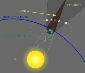
The Photo Collage above: The time-lapse photos depicts the progressive phases of a lunar eclipse over about 5 hours. The full moon's orbit takes it through the Earth's dark shadow, with near-perfect alignment of the moon with the Earth and Sun during "totality." On the night of Sunday Jan 20th the heavens have a nice treat in store for earthbound skygazers in the western hemisphere (weather permitting) - a total Lunar Eclipse! Hope you can join us for an AOC group viewing of this amazing phenomenon which will include the bonus of a short AOC night hike. As hyped by the news media lately, the full moon at the time of this eclipse will be a so-called "Supermoon" - meaning that it is close to "perigee" in its elliptical ~30-day orbit around the Earth, and therefore will be about 10% closer and 20% bigger & brighter than the average monthly full moon. During an eclipse the moon is also called a "Blood Moon" since the refraction of sunlight around the Earth (and "Rayleigh scattering") turns it a reddish hue (as in the middle 3 photos of the above collage). BTW, a nickname for January's full moon is the "Wolf Moon" - a native-American term based on wolves' tendency to howl at the moon on cold winter nights. We'll gather a few minutes before 10:00 PM just inside the Mason Mill Park entrance, by the stone restroom building that adjoins the free parking lot. (See detailed Directions & GPS Info below). We may already be noticing some "penumbral" darkening of the Moon when we arrive as it slowly orbits from right to left into a portion of the Earth's shadow. (See "Eclipse Timetable" below.) After introductions we''ll begin with an easy 1-hour hike (about 2 miles) on the lovely trails that connect Mason Mill & Medlock Parks, during which we expect to have lots of glimpses of the full Moon as it continues to rise higher in the southeastern sky and continues to darken. By about 10:15 we plan to be atop the high wooden deck on the PATH Trail, ~1/4 mile from our cars, and at about 10:33 we should see a well-defined shadow appearing and slowly increasing in size on the left side of the moon as it begins to enter the Earth's dark "umbra" for the "Partial Phase" of the Eclipse. The deck will also be a fine spot for viewing the eerie Total Phase of the Eclipse (when the moon is entirely within the umbra, for about an hour beginning at ~11:41 PM). At about Midnight - after observing totality for about 20 minutes, weather permitting - we'll officially end the event and take the short walk together back to our cars. Feel free to remain and observe longer if you wish - also feel free to "split" early from the group if you like at any time, but please let us know when you do so - it will be easy to direct you back to the parking lot. ECLIPSE PHASE TIMETABLE for the Western Hemisphere using Eastern Standard Time: 
This diagram shows the full moon's orbit taking it eastward (right to left) through FOR MORE LUNAR ECLIPSE INFO + VIDEO CLIPS, ETC. click these links:
http://www.stargazersonline.org/episodes/1901.html http://www.space.com/15689-lunar-eclipses.html https://en.wikipedia.org/wiki/January_2019_lunar_eclipse
CLICK here for an INTERACTIVE MAP / SATELLITE VIEW of the "PATH" SOUTH PEACHTREE CREEK TRAIL and its interconnecting DeKalb County parks (Mason Mill, Medlock, Ira Melton & Clyde Shepherd - also Emory's Lullwater Park): https://pathfoundation.org/trails/south-peachtree-creek-trail/ | |||||||
| |||||||
| How to Get There: | |||||||
| Event Directions: | FROM the I-85 CLAIRMONT ROAD EXIT in NE METRO ATLANTA to our MASON MILL PARK Meetup Spot: (For a zoomable color MAP and satellite view of this spot and its vicinity click on the square blue & green "Event Location" near the top of this article.) 1. From the I-85 "Clairmont Road" Exit (Exit #91) in NE Atlanta take Clairmont Rd southward (toward Decatur) about 2.3 miles to the traffic light at McConnell Drive. (This is the next light south of the big Clairmont/ North Druid Hills intersection. If you reach the huge VA Hospital you've gone 1/2 mile too far!) GPS and MAPS.GOOGLE.com USERS: Feel free to augment my above verbal directions by entering as your Destination Address these concise Lat/Lon coordinates for our meetup spot, being sure to include the comma and minus sign: 33.8079, -84.3066 | ||||||
| Notes: | |||||||
|
* We encourage all members to follow our Etiquette Guidelines while participating in AOC events. | |||||||
| Cost Includes: | Free Event with Free Parking! | ||||||
Cancellation/Partial Attendance: Please review the AOC cancellation policy. | |||||||