Berkeley Lake - Thursday Evening Hike | |||||||
| The Basics: | |||||||
| Event Type: | Urban Hike | ||||||
| Event Location: |
4040 S. Berkeley Lake Road NW Berkeley Lake, GA 30096


| ||||||
| Date(s) & Time: | Thu, May 4 2023 6:00 pm >> Thu, May 4 2023 8:00 pm | ||||||
| Registration Opens: | Mon, May 1 2023 9:00 pm | ||||||
| Registration Cut Off: | Thu, May 4 2023 6:00 pm | ||||||
| Event Duration: | 2 Hours | ||||||
| Difficulty Rating: | D2: Easy to Moderate (Exploratory) | ||||||
| Distance: | 6 Miles | ||||||
| Pace: | Moderate | ||||||
| Trip Leader(s): | Ron Ramspeck Email Trip Leader(s) Email Trip Leader(s)
You must be logged in to get the Trip Leader contact information. | ||||||
| Member Cost: | None | ||||||
| Participant Info: | |||||||
| Who's Invited: | Members Only, 21 And Older Only | ||||||
| Maximum Group Size: | 8 | ||||||
| Minimum Group Size: | 3 | ||||||
| Number Registered So Far: | 3 / 0 (To see who's signed up, log in to the Member Area) | ||||||
| Are Dogs Permitted: | No | ||||||
|
Note: This is an "EXPLORATORY" trip. This means that there are parts of this trip, or perhaps the whole trip, that is new to your Trip Leader(s). However, they are confident that this will not be an issue. This note is here so that you can make an informed decision. When a Trip Leader isn't personally familiar with a trip, there is an increased chance of things not going as planned and you need to be prepared. The Trip Leader may have additional details in the itinerary. | |||||||
| Itinerary: | |||||||
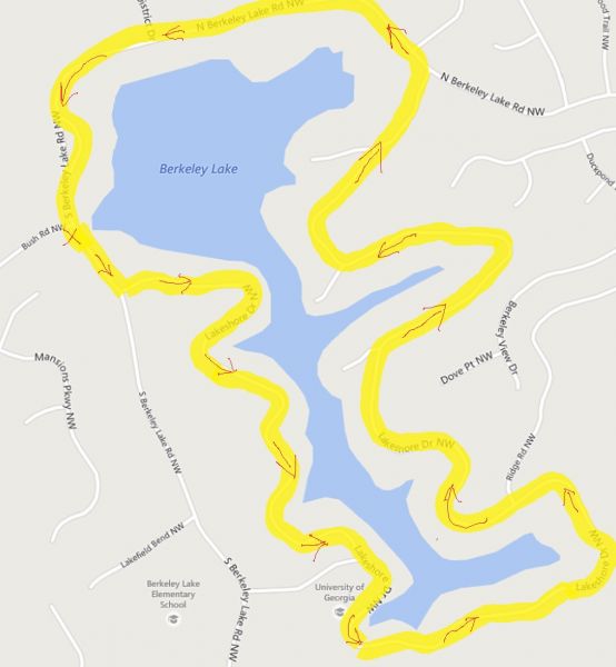
Please join me for this approximately five to six - mile urban hike around Berkeley Lake and some surrounding streets. Our starting and finish point with be the Berkeley Lake City Hall parking lot. This hike is challenging with frequent hills and a 2.7 to 3 mph hiking speed. There are not a lot of pure flat stretches. The hike will take place on streets and sidewalks. Since there are cars, please wear light colored or reflective clothing. Fortunately, the traffic is usually infrequent with friendly drivers that slow down when they see walkers!
Required skills: Good attitude Ability to wave and say hello to the friendly drivers and residents Flexibility - This hike has a new addition to the route so the distance and ending time may slightly vary from what is stated
Additional Notes: A special thank you to Tom Jarosz for use of the promotional picture and map. Please refer to the additional notes section as well. Some of the route is not shown.
Berkeley Lake Loop Route:
| |||||||
| |||||||
| How to Get There: | |||||||
| Event Directions: | Address: Berkeley Lake City Hall 4040 S. Berkeley Lake Rd. Berkeley Lake, GA 30096 < GPS Coordinates: 33.9852703, -84.1893776 > 1. From 285, take GA 141 N (Peachtree Industrial Blvd) 2. Take left turn on South Berkeley Rd NW 3. Berkeley Lake City Hall parking lot will be on your left before Bush Road 4. We will gather at the Berkley Lake City Hall parking lot | ||||||
| Notes: | |||||||
|
This hike is not flat and is considered harder compared to hiking Jones Bridge Park, Beltline, Piedmont Park, or Cochran Shoals hike. Event time does not include optional after hike gathering. If you're a Garmin user, please join our 'Atlanta Outdoor Club (AOC) Garmin Users' group to connect with other AOC Garmin users and track your activity. Join us at: https ://connect. garmin.com/modern/group/2255568 How to Walk Up Hills — Walking for Health and Fitness * We encourage all members to follow our Etiquette Guidelines while participating in AOC events. | |||||||
Cancellation/Partial Attendance: Please review the AOC cancellation policy. | |||||||
