 Print-Friendly Version Print-Friendly Version
|
|
Bartram Trail to Rabun Bald and Flat Top Mountain-NEW ROUTE | |||||||
| The Basics: | |||||||
| Event Type: | Hike | ||||||
| Event Location: |
Ingles in Clayton, GA (arrive by 8:40!)


| ||||||
| Date(s) & Time: | Wed, Jan 1 2025 9:20 am >> Wed, Jan 1 2025 2:00 pm | ||||||
| Registration Opens: | Tue, Dec 24 2024 6:00 am | ||||||
| Registration Cut Off: | Tue, Dec 31 2024 4:00 pm | ||||||
| Event Duration: | 4 Hours 40 Minutes | ||||||
| Difficulty Rating: | D5: Difficult (Exploratory) | ||||||
| Distance: | 10.9 Miles | ||||||
| Pace: | Moderate | ||||||
| Trip Leader(s): | Chuck M Email Trip Leader(s) Email Trip Leader(s)
You must be logged in to get the Trip Leader contact information. | ||||||
| Member Cost: | None | ||||||
| Participant Info: | |||||||
| Who's Invited: | Members Only, 21 And Older Only | ||||||
| Maximum Group Size: | 10 | ||||||
| Minimum Group Size: | 3 | ||||||
| Number Registered So Far: | 8 / 0 (To see who's signed up, log in to the Member Area) | ||||||
| Are Dogs Permitted: | No | ||||||
|
Note: This is an "EXPLORATORY" trip. This means that there are parts of this trip, or perhaps the whole trip, that is new to your Trip Leader(s). However, they are confident that this will not be an issue. This note is here so that you can make an informed decision. When a Trip Leader isn't personally familiar with a trip, there is an increased chance of things not going as planned and you need to be prepared. The Trip Leader may have additional details in the itinerary. | |||||||
| Itinerary: | |||||||
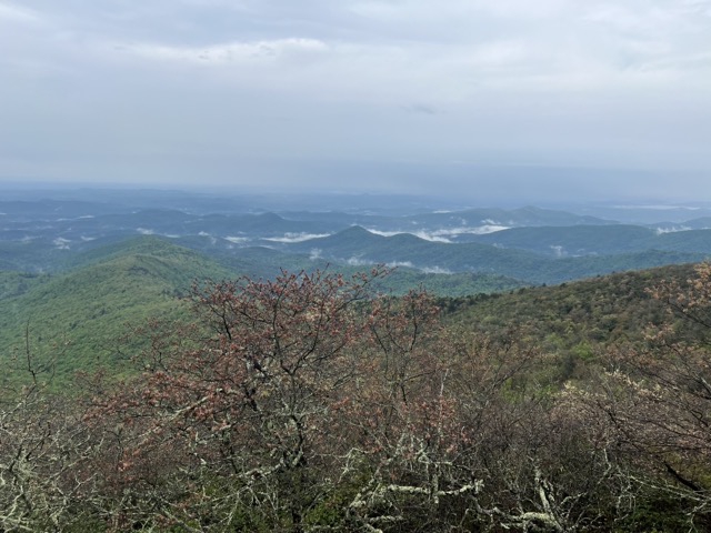
I learned that the water is currently too high to cross Darnell Creek safely, so I have changed the route to approach Rabun Bald from the North on the Bartram Trail. We will pass Rabun Bald to catch some great views from Flat Top Mountain (along with some additional distance and climbing). The hike will still be a D5, but it will have less distance (10.9 miles) and more climbing (3,700 feet). From the (same) carpool, we will have a longer drive to the trailhead, which is almost at the North Carolina border. There we will pick up the Bartram Trail and hike south to Rabun Bald. After reaching Rabun Bald we will hike farther down the Bartram Trail to Flat Top Mountain, where we will pick up some great views before returning to our starting point. I have not hike this section of the Bartram Trail, so it is marked as exploratory, but another AOC hike did the same approach to Rabun Bald recently. Those who are familiar with the Bartram Trail know it is a beautiful trail that is far less travelled than our beloved AT. So we are likely to enjoy some solitude on this hike. There is a stone tower atop Rabun Bald with a wooden platform providing fabulous views across north Georgia, as well as into North Carolina, Tennessee, and South Carolina. After leaving Rabun Bald for Flat Top Mountain, we will get some more great views, then climb Rabun Bald again and head back to our starting point. Somewhere along the way we will find a good place to stop for lunch. Because of the new route, there will not be any water crossing. Parking at the trailhead is still limited, so we will meet at the Clayton Ingles where we will squeeze into the fewest cars possible. Here is a map of the hike: <iframe src="https://www.gaiagps.com/public/63ug1nUaoxppHZAsr13oA4um/?embed=True" style="border:none; overflow-y: hidden; background-color:white; min-width: 320px; max-width:420px; width:100%; height: 420px;" seamless></iframe> | |||||||
| |||||||
| How to Get There: | |||||||
| Event Directions: | We will meet at the Ingles in Clayton. If you type "Ingles Clayton" into your GPS (Google or Apple Maps) it will take you to the right place. Here is a link for Google Maps: https://goo.gl/maps/foL9trA5N VQJxApt5 Park on the right side of the parking lot, and take advantage of the clean restrooms in Ingles (there are no facilities on this hike). You might also consider buying something for lunch. Here we will transfer into two cars. Meeting at the trailhead is not allowed due to the limited parking. Please arrive at the Clayton Ingles by 8:40 so we can depart for the trailhead at 9. | ||||||
| Notes: | |||||||
|
Carpool drivers from the Clayton Ingles can find the trailhead by typing into their GPS: Darnell Creek Horse Trail NOTE: Meeting at the trailhead is not allowed due to the very limited parking available. * We encourage all members to follow our Etiquette Guidelines while participating in AOC events. | |||||||
Cancellation/Partial Attendance: Please review the AOC cancellation policy. | |||||||
 Calendar of Events
 Event Places