REGISTRATION REQUIRED: Once you've reviewed the event details, and decided you'd like to join us, you
MUST sign up at the
bottom of this page.
Three Forks Waterfalls hiking and swimming

|
|
The Basics: |
| Event Type: |  | Hike |  |
|
Event Location: |  |
Rabun County, GA


|  |
| Date(s) & Time: |  | Sat, Aug 4 2012
11:30 am >> Sat, Aug 4 2012 6:00 pm (Carpool Departure: 9:00 am *log in for location*)
|  |
| Registration Opens:
|  |
Mon, Mar 12 2012 8:35 pm
|  |
| Registration Cut Off:
|  |
Thu, Aug 2 2012 6:00 pm
|  |
| Event Duration: |  | Per Itinerary |  |
| Difficulty Rating: |  | D3: Moderate |  |
| Distance: |  | 8.3 Miles |  |
| Pace: |  | Moderate |  |
Trip Leader(s):
|  | Tony C
Jon Miner
 Email Trip Leader(s) Email Trip Leader(s)
You must be logged in to get the Trip Leader contact information.
|  |
| Member Cost: |  | None |
|
| Participant Info: |
| Who's Invited: |  |
Members Only, 21 And Older Only
|  |
| Maximum Group Size: |  | 14 |
| Minimum Group Size: |  | 5 |
| Number Registered So Far: |  |
7 / 0 (To see who's signed up, log in to the Member Area)
|
| Are Dogs Permitted: |  |
No
|
|
| Itinerary: |
This is probably the most popular waterfall hike the AOC offers every year and for good reason...the scenery is just gorgeous and the multiple swimming breaks are so refreshing on a hot summers day. Fellow trip leader Dean M turned us onto this route, and hopefully he and some others will lead this one multiple times this year.
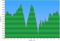
 We have done this as a D4 hike, but going to try it as a D3 this time and keep the pace more moderate. The total distance is 8.3 miles and there is about 1800' of total ascent...no big mountains to climb but quite a few short steep uphills and rolling terrain. But we will take them slowly. Also, the hiking is broken up by three long swimming breaks, so it doesn't really feel like 8 miles at the end. But if you are in solid D3 type shape, you should have no problems. We have done this as a D4 hike, but going to try it as a D3 this time and keep the pace more moderate. The total distance is 8.3 miles and there is about 1800' of total ascent...no big mountains to climb but quite a few short steep uphills and rolling terrain. But we will take them slowly. Also, the hiking is broken up by three long swimming breaks, so it doesn't really feel like 8 miles at the end. But if you are in solid D3 type shape, you should have no problems.
This hike offers no less than four beautiful waterfalls...actually even a more if you count some of the smaller cascades along the route.
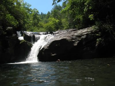
We will begin by hiking 3.2 miles to Singley's Falls on Overlfow Creek. This is a 20 foot beauty that empties into a deep swimming hole. We will take about a 45 min break here to cool off and swim and relax.
From here we have 1.8 miles to go to Three Forks itself, so named for the confluence of Overflow, Holcomb and Big Creeks end near this spot...they combine to form the West Fork of the Chattooga River. Plan on a long and leisurely (at least an hour) break here for lots of swimming and exploring. There are some relaxing rock jacuzzis to soak in...and you can hike a few hundred feet up Holcomb Creek to a beautiful hidden gorge with numerous little falls coming down it. It looks like something out of a movie.

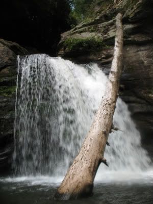
After our long break at Three Forks, we will hit the trail again....it is just half a mile to the first of two waterfalls on Big Creek. We will snap a few picshere and then another half mile to the main Big Creek waterfall. This one is 50' high with multiple levels. We will take another long break here as this is one of the prettiest spots on the entire hike and maybe the best swimming hole.
After this last waterfall, it is 2.3 mi back out to the trailhead. Afterwards, we can head home or stop in Clayton for a bite to eat, depending on what each car would like to do. It will be a long day but well worth it to fully experience one of the most beautiful areas in the state, if not the entire Southeast.
Elevation profile:
Click for larger version:

|
|
Required Items to Bring:
- water
- food/snacks
- hiking boots/shoes |  | Recommended Items to Bring:
Use our Event Checklists to make sure you have everything you need.
- Swimsuit
- sunscreen
- bug spray | |
|
| How to Get There: |
| Event Directions: |  | From Clayton, GA, head east on Warwoman Road for 14 miles until its end at Highway 28. Turn left (north) and follow Hwy 28 4.4 miles to the trailhead on the left side of the road (just 1.3 miles south of the NC border). |  |
| Carpool to Event Distance (round trip): |  | 213Mile(s) |
| Carpool Departure Time: |  |
9:00 am
|
| Carpool Location: |  |
Log in for location
|
| Carpool Directions: |  |
Log in for directions
|
| Carpool Cost: |  |
Estimated cost per vehicle for this event is $85.20 using a reimbursement rate guideline of $0.400 per mile. The total amount should be divided by the number of people in the vehicle, including the driver. This is a guideline, not a rule, for drivers but the cost should not be higher unless there are extenuating circumstances.
|
|
| Notes: |
|
|
|
Cancellation/Partial Attendance: Please review the AOC cancellation policy. |


 Print-Friendly Version


 Email Trip Leader(s)