 Print-Friendly Version Print-Friendly Version
|
|
Peakbagging in South Carolina | |||||||
| The Basics: | |||||||
| Event Type: | Backpacking | ||||||
| Event Location: | Table Rock State Park | ||||||
| Date(s) & Time: | Sat, Feb 16 2008 11:00 am >> N/A (Carpool Departure: 8:30 am *log in for location*) | ||||||
| Registration Opens: | Tue, Jan 29 2008 12:00 am | ||||||
| Registration Cut Off: | Wed, Feb 13 2008 11:59 pm | ||||||
| Event Duration: | 2 days | ||||||
| Difficulty Rating: | D5: Difficult | ||||||
| Trip Leader(s): | Bob Bunner Email Trip Leader(s) Email Trip Leader(s)
You must be logged in to get the Trip Leader contact information. | ||||||
| Member Cost: | None | ||||||
| Participant Info: | |||||||
| Who's Invited: | Members Only, 21 And Older Only | ||||||
| Maximum Group Size: | 10 | ||||||
| Minimum Group Size: | 6 | ||||||
| Number Registered So Far: | 9 / 0 (To see who's signed up, log in to the Member Area) | ||||||
| Are Dogs Permitted: | No | ||||||
| Itinerary: | |||||||
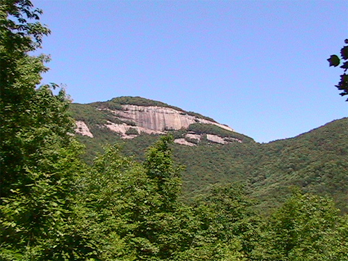
| On this backpacking trip, we'll summit the two tallest peaks in South Carolina. From Table Rock State Park, we will climb about 2,000 feet in elevation for the first three miles and summit Pinnacle Mountain. Then, we'll hike along the Foothills Trail to our campsite near the remnants of the home of an old settler, which will be about 7.8 miles from where we started at the trailhead. Sassafras Mountain is the tallest peak in South Carolina at 3,560 feet and is about 1.2 miles from where we camp. We can either bag it in the evening before sunset or get up early and bag it in the morning. On the way back, we'll have the choice of returning on the Panther Gap trail and hiking up Table Rock Mountain. We'll see how ambitious everyone wants to be. You need to be in really good shape for this hike. If you sign up and I do not know you, I will contact you to make sure you are fit enough for this trip. Also, we could be facing extreme winter conditions. I will cancel the hike if it looks like temperatures will be significantly below freezing, say 10 degrees or less. But there is no way I will know what the actual temperature will be, especially at night, so if you have any questions about whether your gear will keep you warm enough, contact me or choose another trip. We'll know more as it gets closer to the date of the trip. | |||||||
| |||||||
| How to Get There: | |||||||
| Event Directions: | Go I-85 north into SC. Take Exit 21, US 178, and go toward Liberty. Stay on US 178 for about 33 miles and take a right onto SC 11, also known as the Cherokee Foothills Scenic Hwy. Go about 4.3 miles and take a right into Table Rock State Park in Pickens, SC. | ||||||
| Carpool to Event Distance (round trip): | 270Mile(s) | ||||||
| Carpool Departure Time: | 8:30 am | ||||||
| Carpool Location: | Log in for location | ||||||
| Carpool Directions: | Log in for directions | ||||||
| Carpool Cost: | Estimated cost per vehicle for this event is $108.00 using a reimbursement rate guideline of $0.400 per mile. The total amount should be divided by the number of people in the vehicle, including the driver. This is a guideline, not a rule, for drivers but the cost should not be higher unless there are extenuating circumstances. | ||||||
| Notes: | |||||||
|
South Carolina State Parks will charge us $2 per person per day up
to $4 per car, so bring some parking money and some gas money
for the driver. Also, the group may want to stop and eat dinner on
the way home. * We encourage all members to follow our Etiquette Guidelines while participating in AOC events. | |||||||
Cancellation/Partial Attendance: Please review the AOC cancellation policy. | |||||||
 Calendar of Events
 Event Places